![Lower Mustang Trek 8 Days [2026]](https://hstnpl.com/assets/images/logo_icon/logo.png)
Office Address
Comapany Address
Phone Number
Email Address
info@ hstnpl.com
Comapany Address
info@ hstnpl.com
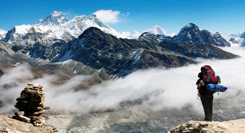
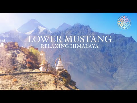
The 8-Day Lower Mustang Trek explores the arid trans-Himalayan rain shadow of the Kali Gandaki Valley. Perched between the towering 8,000-meter massifs of Dhaulagiri (8,167 m) and Annapurna I (8,091 m), this cultural route traces historic salt trading tracks. You will walk through wind-carved canyons, explore the 500-year-old mud-brick alleyways of Kagbeni, discover the ancient Bonpo village of Lupra, and visit the sacred 108 water spouts of Muktinath (3,760 m) before winding through the stone-paved Thakali apple capital of Marpha.
Requires an Annapurna Conservation Area Project (ACAP) Permit and TIMS Card. No Restricted Area Permit (RAP) is needed for Lower Mustang south of Kagbeni. Maximum altitude reaches 3,760 m at Muktinath. Afternoon winds in the Kali Gandaki gorge are consistently strong, so morning trekking schedules are strictly followed.
Board a morning flight from Pokhara, flying directly through the Kali Gandaki gorge between Annapurna and Dhaulagiri to land on the airstrip at Jomsom. Assemble your daypacks, meet your local porter team, and begin walking north along the wide, gravelly riverbed of the Kali Gandaki. Search for prehistoric fossilized ammonites (Saligrams) along the riverbanks as you approach Kagbeni—a 500-year-old mud-brick fortress settlement serving as the border checkpoint into restricted Upper Mustang.
Climb steadily out of Kagbeni up the desert hillsides of the Mustang plateau. The canyon walls turn shades of red, ochre, and yellow under the trans-Himalayan sun. Pass through Khingar and ascend to the fortress village of Jharkot (3,550 m) to visit its centuries-old Sakya Buddhist monastery and traditional Tibetan herbal medicine center. Continue climbing the open barren plateau to the sacred shrine town of Muktinath.
Visit Muktinath Temple in the morning, observing Hindu and Buddhist pilgrims bathing beneath the 108 holy brass water spouts and viewing the eternal natural gas flame at Jwala Mai. Avoid the main vehicle road by taking the quiet, high trail through Lupra Pass (3,900 m). Drop down a canyon to Lupra, the only surviving Bonpo village in Lower Mustang. Tour the ancient Bon monastery before following the Panda Khola riverbed back into Jomsom.
Walk south along the flat valley floor past apple orchards to the whitewashed Thakali town of Marpha. Stroll through narrow stone-paved lanes, visit the hilltop monastery, and sample local dried apples and cider. Continue through the open valley alongside pine groves to Tukuche, an ancient trading hub featuring historic Thakali merchant mansions that once controlled cross-border salt caravans from Tibet.
Cross the riverbed via small wooden bridges to follow quiet trails on the eastern bank. The arid landscape transitions into thick pine and birch woodlands. Trek beneath the colossal ice cliffs of Dhaulagiri I (8,167 m) looming directly overhead. Arrive in the alpine hamlet of Kalopani, which delivers a direct, unobstructed perspective of Annapurna I, Nilgiri, and the world's deepest gorge.
Descend steeply out of the alpine zone following the thunderous roar of the Kali Gandaki River. Pass through Ghasa, the southern border of Mustang district, and stop at the cascading Rupse Chhahara waterfall. As the climate turns lush and subtropical, arrive in Tatopani. Spend the evening resting in the natural thermal pools situated along the riverbank.
Board a private 4WD vehicle from Tatopani, driving along the Kali Gandaki river canyon to the district hub of Beni. Join the paved highway winding past green terraced rice hills, rivers, and small bazaar towns before arriving back at your lakeside hotel in Pokhara for an evening of rest.
Transfer to Pokhara Airport for a 25-minute morning flight across the Himalayan foothills back to Kathmandu, or take a scenic drive along the Prithvi Highway. Our airport team handles your private hotel drop-off, concluding the Lower Mustang tour.
Based On 0 Review
Your email address will not be published
We offer Everest Base Camp, Annapurna Base Camp, Langtang, and custom treks suitable for all skill levels.
Yes, all treks include experienced guides, and porters are available on request for extra support.
Absolutely! Treks, safaris, boating trips, and peak climbing expeditions can be tailored to your preferences.
Book via our website, email, or Pokhara office. We’ll confirm availability and payment instructions promptly.
Packages include accommodation, meals, guide and porter services, permits, local transport, and itinerary-based activities
Essentials include trekking shoes, warm clothing, backpack, water bottle, sunscreen, hat, and basic medical supplies.
es! Safaris in Chitwan and Bardia National Parks are family-friendly, with experienced guides and safe wildlife observation.
You may see tigers, rhinos, elephants, crocodiles, deer, and various birds. Guides ensure safe and responsible viewing.
Strongly recommended for trekking, climbing, and adventure activities to ensure safety and emergency coverage.
Transportation from your hotel or nearby hub to the trek starting point is included in all packages.
Yes! Beginners are welcome with proper guidance, acclimatization schedules, and experienced support staff.
We recommend booking at least 1–2 months before peak trekking seasons (Spring: Mar–May, Autumn: Sep–Nov)
Yes, we provide discounts for families, groups, or corporate bookings. Contact us for a custom quote.


"I did the 10 days ABC trek with Batti, a very good guide. The trek was amazing! First, I met the owner who gave me lots of information and advices for the trek. This agency is very..."

"처음부터 끝까지 완전 퍼펙트 했습니다 ^^ 부펜 사장님과 미팅을 시작으로 3박 4일 동거동락을 함께했던 가이드와 포터 까지 친절하고 섬세한 보살핌 덕분에 뷰 포인트에서 장엄한 일출까지 보..."

"I cannot praise Himalaya Safety enough for organizing my unforgettable Panchase trek in Nepal! Bhupi’s expertise in advising me on the perfect trek for my preferences was invaluabl..."

"I’ve just returned from a 9 day Annapurna base camp trek. The trek was very well planned out. Pre trek itinerary and information was excellent. The guides, Madhav, Santosh and Kim..."

"I booked a day rock climbing and Mardi Himal trek through Himalaya safety adventure. I had a fantastic day climbing with Bhoopi. He was patient, kind and a brilliant climbing partn..."

"We had an amazing rock climbing session with Bhoopie in Pokhara – truly an unforgettable experience! Bhoopie’s expertise and calm guidance made us feel safe and confident throughou..."

"마르디히말 트래킹과 패러글라이딩, 비행기를 여기서 예약했어요. 가이드와 포터 모두 친절했어요. 특히 가이드는 한국말을 잘했고, 저랑 엄마가 계단을 힘들어했는데 최대한 계단 없는 길로 가..."

"Amazing trek experience! Kind and helpful owner, friendly and professional guide, and top-notch safety standards. Couldn’t have chosen better – highly recommend!"

"We recently went on a Lower Mustang trip, and it was truly a remarkable adventure, thanks to the Himalaya Safety Treks and Expedition that organised everything for us. From the mom..."

"I cannot thank Himalayan Safety and specifically Bhupendra enough for facilitating the experience of a lifetime. I came to him with a specified set of requirements, and still thoro..."

"Had the pleasure of meeting Bhupendra from Himalaya Safety Treks & Expedition whilst staying in Pokhara. After a long and insightful conversation we decided to climb Mardi Himal v..."

"I cannot praise Himalaya Safety enough for organizing my unforgettable Panchase trek in Nepal! Bhupi's expertise in advising me on the perfect trek for my preferences was invaluabl..."

![Lower Mustang Trek 8 Days [2026]](https://hstnpl.com/assets/images/plan/6a8cac967059a1787604118.png)
![Lower Mustang Trek 8 Days [2026]](https://hstnpl.com/assets/images/plan/6a8cac96b4d991787604118.png)
![Lower Mustang Trek 8 Days [2026]](https://hstnpl.com/assets/images/plan/6a8cac97008bc1787604119.png)